Lightning
Lightning Overview
The purpose of the lightning feature is to demonstrate a dynamic weather pattern in a given location.
| Visual Examples | |
|---|---|
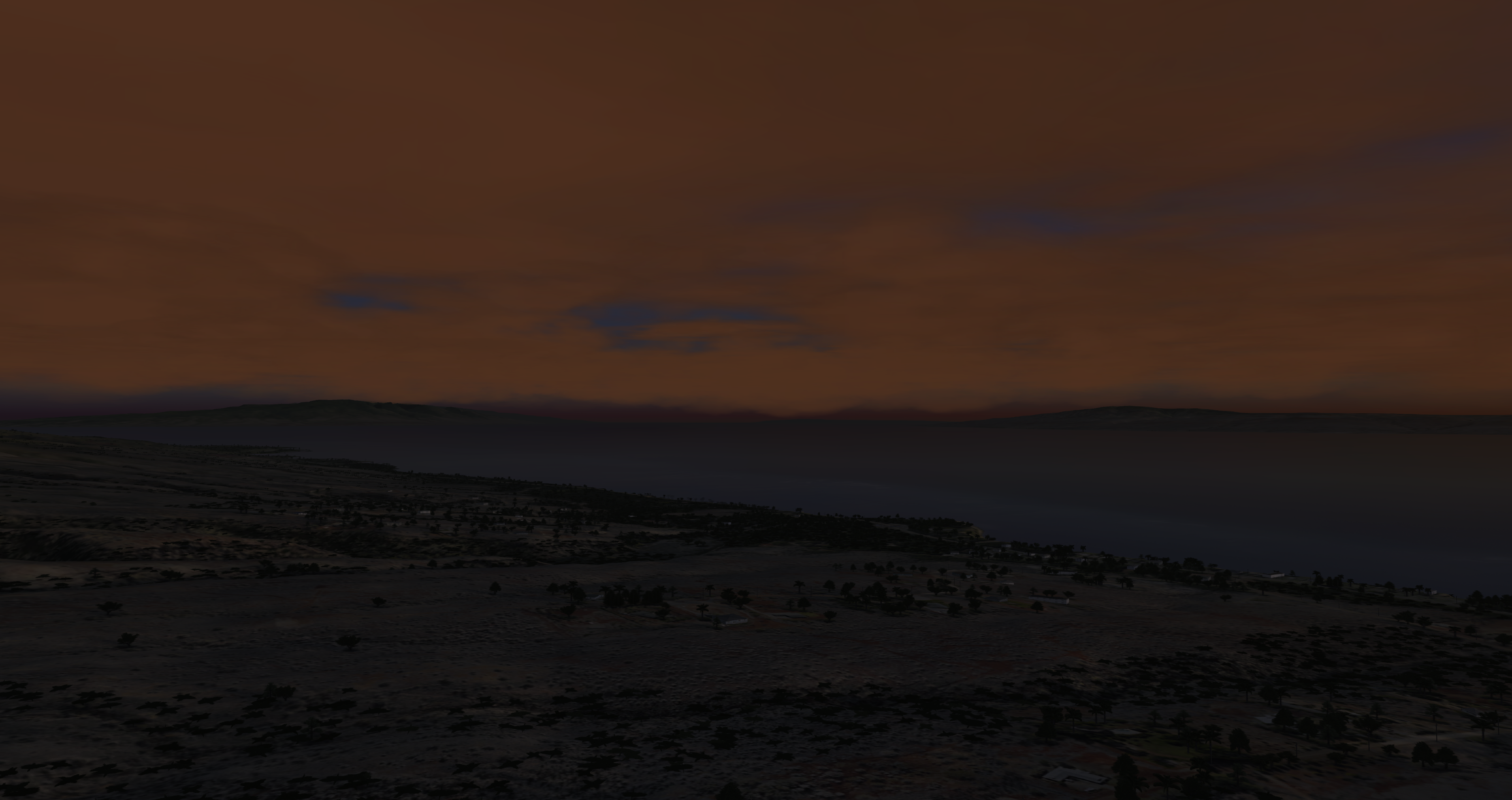
A scene before the lightning flashes across the sky
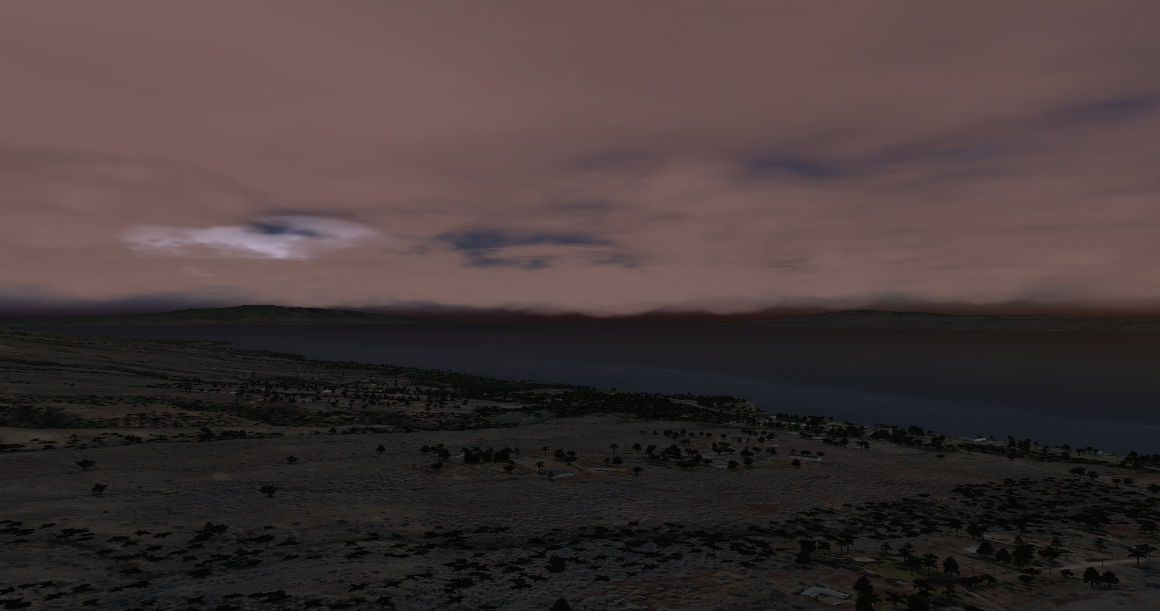
| A scene of the lightning flashing across the sky
|
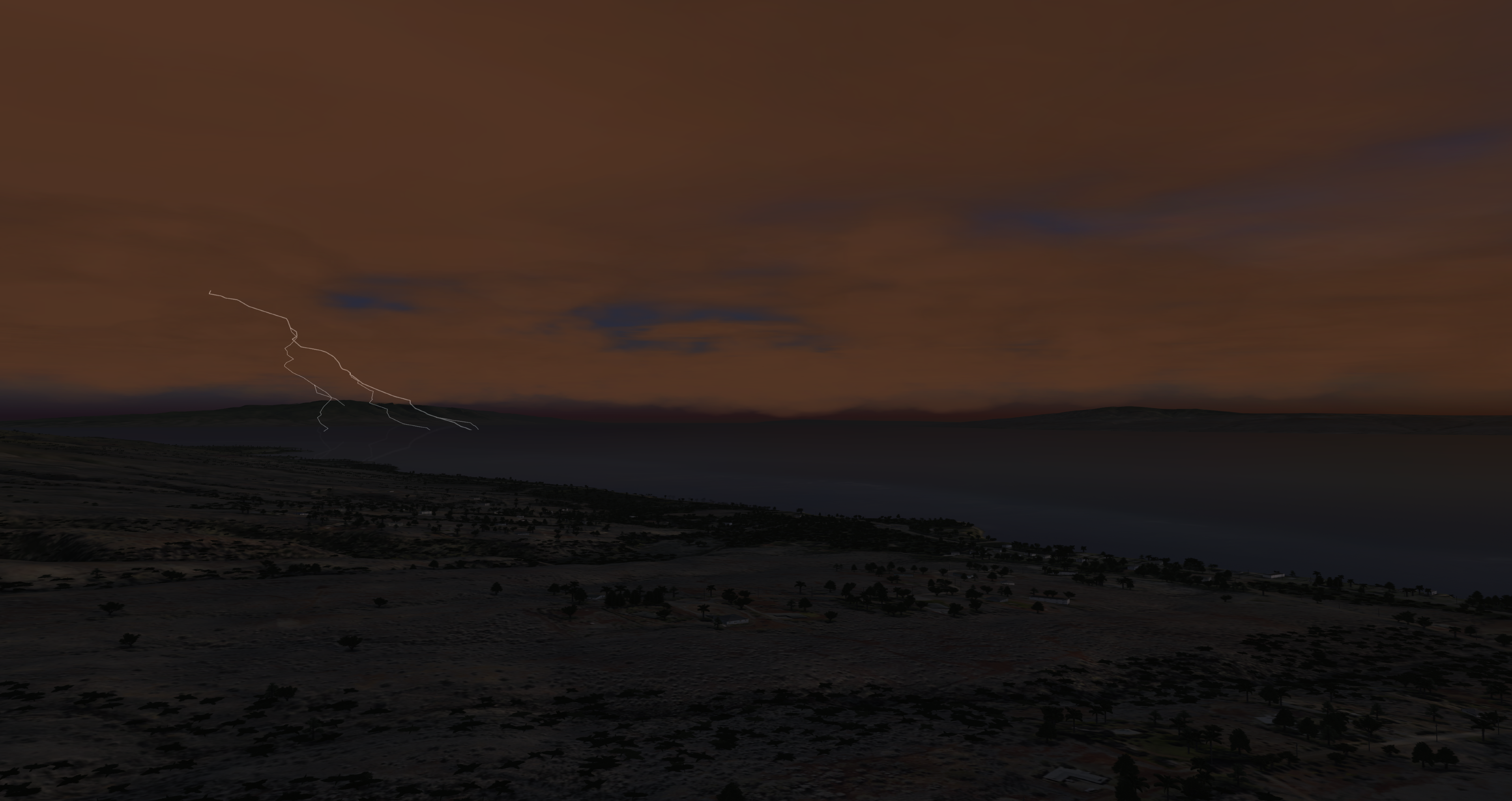
A scene of lightning striking; its reflection can be seen in the water
| |
Lightning Configuration
Lightning Token Configuration
| Token Name | Type | Default Value | Accepted Values | Category | Description |
|---|---|---|---|---|---|
| AutoCloudCulturalIllum | BOOL | OFF | ON, OFF, 1, 0, TRUE, FALSE | Rendering Weather | |
| AutoCloudCulturalIllumCount | FLOAT | 25000 | -FLOAT_MAX to FLOAT_MAX, inclusive | Rendering Weather | |
| AutoCloudCulturalIllumFactor | FLOAT | 1 | -FLOAT_MAX to FLOAT_MAX, inclusive | Rendering Weather | |
| AutoCloudCulturalIllumViewCount | FLOAT | 15000 | -FLOAT_MAX to FLOAT_MAX, inclusive | Rendering Weather | |
| BlackSky | BOOL | OFF | ON, OFF, 1, 0, TRUE, FALSE | Rendering Weather | |
| CloudCulturalIllumDefault | FLOAT | 0 | -FLOAT_MAX to FLOAT_MAX, inclusive | Rendering Weather | |
| CloudMoonIlluminationFactor | FLOAT | 1 | 0 to 1, inclusive | Rendering Weather | Factor to control moon cloud/fog illumination in OTW/CCD |
| DisableCloudSort | BOOL | OFF | ON, OFF, 1, 0, TRUE, FALSE | Rendering Weather | |
| InsideCloudVisibilityFactor | FLOAT | 1 | Greater than 0 Less than or equal to FLOAT_MAX ( 0 < x <= FLOAT_MAX ) | Rendering Weather | |
| LayeredHazeColors | BOOL | ON | ON, OFF, 1, 0, TRUE, FALSE | Rendering Weather | Sets whether layered haze colors are used If: 1) OTW or RADAR 2) Not Planter 3) HDRLighting is OFF or ON. Ignored and implicitly forced ON for sensor types where HDRLighting ADVANCED is active. Ignored and implicitly forced OFF if: HDRLighting is OFF or ON, and 1) Sensor type != OTW or RADAR or 2) Is Planter. |
| LayeredHazeDensityInitValue | FLOAT | 0.66 | -FLOAT_MAX to FLOAT_MAX, inclusive | Rendering Weather | |
| LightInsideCloudRange | FLOAT | 100 | Greater than 0 Less than or equal to FLOAT_MAX ( 0 < x <= FLOAT_MAX ) | Rendering Weather | |
| LightningIntensityFactor | FLOAT | 1 | -FLOAT_MAX to FLOAT_MAX, inclusive | Rendering Weather | |
| RainColorFactor | FLOAT | 1 | -FLOAT_MAX to FLOAT_MAX, inclusive | Rendering Weather |
Lightning Data Configuration
None.
Lightning Usage
Lightning ICD Interface
| Nova Variable | Description |
|---|---|
| ios2ig.dat.lightning | Severity level of the lighting. 0: Off 1: Less severe to 3: More severe |
Lightning Runtime Operation
Runtime Scenario - Enabling Lightning
If using AeHost:
- Locate the Precipitation section.
- Locate the Lightning Enable, Severity line and click its checkbox; change its value to 2.
If setting values directly in Spy:
- Set ios2ig.dat.lightning to 2.
Lightning CIGI Packets
Weather Control Packet
| Layer ID | Weather Effect | SpyClient Mapping | Supported Fields | Description |
|---|---|---|---|---|
| 0 | Ground Fog | ios2ig.dat.fog | Weather Enable | Off / On Flag (0, 1) |
| ios2ig.dat.fog_layer_floor | Base Elevation | Top altitude of full fog where visibility is equal to Visibility Range. (The fog base always extends to the ground - ownship cannot punch below layer). | ||
| ios2ig.dat.fog_layer_ceiling | Thickness (Summed with base elevation) | Thickness of transition band between Base Elevation (full fog) and no fog. | ||
| ios2ig.dat.fog_layer_range | Visibility Range | Visibility range within ground fog. | ||
| 1 | Cloud Layer 1 | N/A | Weather Enable | Off / On Flag (0, 1) |
| ios2ig.dat.cloud_layer1 | Cloud Type | See Cloud Types. | ||
| 7th bit of ios2ig.dat.cloud_layer1 | Scud Enable | Off / On | ||
| ios2ig.dat.cloud_thick1 | Transition | Transition region for scud. | ||
| ios2ig.dat.cloud_bottom1 | Base Elevation | Lowest Cloud level (meters). | ||
ios2ig.dat.cloud_height1 | Top Height (Summed with thickness) | For types 3 and 9 - 12: Top height of cloud layer (Base Elevation + Thickness). Thickness ignored for type 10. All other types: Transition layer thickness - these clouds are 2D. | ||
| ios2ig.dat.cloud_layer_color1 | Severity | Color Enumeration 0: Default 1: Darkest - 4: Lightest | ||
| ios2ig.dat.cloud_layer_density1 | Coverage (Types 9 - 12 only) | Density: 0 - 100 (Less Dense - More Dense). | ||
| ios2ig.dat.cloud_layer_softness1 | Aerosol (Types 9 - 12 only) | Softness: -127 - 127 (Sharper Edge - Softer Edge). 0 is default. | ||
| 2 | Cloud Layer 2 | N/A | Weather Enable | Off / On Flag (0, 1) |
| ios2ig.dat.cloud_layer2 | Cloud Type | See Cloud Types. | ||
| 7th bit of ios2ig.dat.cloud_layer2 | Scud Enable | Off / On | ||
| ios2ig.dat.cloud_thick2 | Transition | Transition region for scud. | ||
| ios2ig.dat.cloud_bottom2 | Base Elevation | Lowest Cloud level (meters). | ||
ios2ig.dat.cloud_height2 | Top Height (Summed with thickness) | For types 3 and 9 - 12: Top height of cloud layer (Base Elevation + Thickness). Thickness ignored for type 10. All other types: Transition layer thickness - these clouds are 2D. | ||
| ios2ig.dat.cloud_layer_color2 | Severity | Color Enumeration 0: Default 1: Darkest - 4: Lightest | ||
| ios2ig.dat.cloud_layer_density2 | Coverage (Types 9 - 12 only) | Density: 0 - 100 (Less Dense - More Dense) | ||
| ios2ig.dat.cloud_layer_softness2 | Aerosol (Types 9 - 12 only) | Softness: -127 - 127 (Sharper Edge - Softer Edge) 0 is default | ||
| 3 | Cloud Layer 3 | N/A | Weather Enable | Off / On Flag (0, 1) |
| ios2ig.dat.cloud_layer_color3 | Severity | Color Enumeration 0: Default 1: Darkest - 4: Lightest | ||
| ios2ig.dat.cloud_layer_density3 | Coverage (Types 9 - 12 only) | Density: 0 - 100 (Less Dense - More Dense) | ||
| ios2ig.dat.cloud_layer_softness3 | Aerosol (Types 9 - 12 only) | Softness: -127 - 127 (Sharper Edge - Softer Edge). 0 is default. | ||
| 4 | Rain | N/A | Weather Enable | Off / On Flag (0, 1) |
ios2ig.dat.rain ios2ig.dat.inten_rain | Severity | Rain Severity 1: Less Severe - 5: More Severe | ||
| 5 | Snow | N/A | Weather Enable | Off / On Flag (0, 1) |
| ios2ig.dat.snow | Severity | Snow Severity 1: Less Severe - 5: More Severe | ||
| 10 | Lightning (Aechelon Extension) | ios2ig.dat.lightning | Weather Enable | Off / On Flag (0, 1) |
| Severity | 1: Less Severe - 3: More Severe | |||
| 11 | Sea State (Aechelon Extension) | N/A | Weather Enable | Off / On Flag (0, 1) |
| ios2ig.dat.sea_state.sea_state | Severity | Sea State 1: Calm - 5: Not Calm | ||
| ios2ig.dat.sea_state.sea_roughness | Thickness | Sea Roughness 1: Less Rough - 5: More Rough | ||
| ios2ig.dat.sea_state.sea_wind_speed | Horizontal Wind Speed | Wind speed for waves (knots). | ||
| ios2ig.dat.sea_state.sea_wind_dir | Wind Direction | Wind direction for waves (degrees). | ||
| 12 | Haze (Aechelon Extension) | N/A | Weather Enable | Off / On Flag (0, 1) |
ios2ig.dat.visib_general ios2ig.dat.visib_fog ios2ig.dat.fog_range | Visibility Range | Range (meters). | ||
ios2ig.dat.layered_haze_intensity | Coverage | Intensity of layered haze effect (0.0 - 1.0). | ||
ios2ig.dat.haze_tint | Thickness | De-saturate blue tint of haze effect (0.0 - 1.0). 0.0 is default value. | ||
| 13 | Windshield Wipers (Aechelon Extension) | N/A | Weather Enable | Thickness = (0.0 - 1.0) Speed |
ios2ig.dat.windshield_wipers | Thickness | Speed 0.0: Slower - 1.0: Faster | ||
| 14 | Tide Level (Aechelon Extension) | ios2ig.dat.sea_state.tide_level | Thickness | Tide (feet). |
| 15 | Patchy Fog (Aechelon Extension) | N/A | Weather Enable | Off / On Flag (0, 1) |
ios2ig.dat.fog | Coverage | Coverage Type | ||
ios2ig.dat.fog_layer_floor | Base Elevation | Top altitude of full fog where visibility is equal to Visibility Range (the fog base always extends to the ground, 0 MSL) | ||
ios2ig.dat.fog_layer_ceiling | Thickness (Summed with base elevation) | Thickness of transition band between Base Elevation (full fog) and no fog | ||
ios2ig.dat.fog_layer_range | Visibility Range | Range. | ||
ios2ig.dat.varying_fog | Transition | Variance 0.0 - 1.0 | ||
| 16 | Wet Runway (Aechelon Extension) | N/A | Weather Enable | Off / On Flag (0, 1) |
ios2ig.dat.wet_runway | Severity | Effect enumeration 0: Auto 1: Clear 2: Rain 3: Snow 4: Ice 5: Patchy Rain 6: Patchy Snow 7: Patchy Ice 8: Sand | ||
| 17 | Sea Current (Aechelon Extension) | N/A | Weather Enable | Off / On Flag (0, 1) |
ios2ig.dat.sea_state.sea_current_dir | Wind Direction | Wind direction for sea targets (degrees). | ||
ios2ig.dat.sea_state.sea_current_speed | Horizontal Wind Speed | Wind speed for sea current (knots). | ||
ios2ig.dat.sea_state.sea_current_amplitude | Base Elevation | Wave amplitude in meters. | ||
ios2ig.dat.sea_state.sea_current_period | Thickness | Wave period in meters. | ||
| 18 | Alpenglow (Aechelon Extension) | N/A | Weather Enable | Off / On Flag (0, 1) |
ios2ig.dat.alpenglow | Thickness | Alpenglow effect intensity 0.0 - 1.0 | ||
| 19 | Wind Layer 1 (Aechelon Extension) | N/A | Weather Enable | Off / On Flag (0, 1) Note that the Atmosphere Control packet's wind settings set all wind layers; to set them individually, you must send this packet after the Atmosphere Control packet |
h2ig.dat.wind_dir[0] | Wind Direction | Wind direction (degrees). | ||
h2ig.dat.wind_veloc[0] | Horizontal Wind Speed | Wind speed (knots). | ||
h2ig.dat.wind_layer_hgt[0] | Base Elevation | Wave height in meters. | ||
| 20 | Wind Layer 2 (Aechelon Extension) | N/A | Weather Enable | Off / On Flag (0, 1) Note that the Atmosphere Control packet's wind settings set all wind layers; to set them individually, you must send this packet after the Atmosphere Control packet |
h2ig.dat.wind_dir[1] | Wind Direction | Wind direction (degrees). | ||
h2ig.dat.wind_veloc[1] | Horizontal Wind Speed | Wind speed (knots). | ||
h2ig.dat.wind_layer_hgt[1] | Base Elevation | Wave height in meters. | ||
| 21 | Wind Layer 3 (Aechelon Extension) | N/A | Weather Enable | Off / On Flag (0, 1) Note that the Atmosphere Control packet's wind settings set all wind layers; to set them individually, you must send this packet after the Atmosphere Control packet |
h2ig.dat.wind_dir[2] | Wind Direction | Wind direction (degrees). | ||
h2ig.dat.wind_veloc[2] | Horizontal Wind Speed | Wind speed (knots). | ||
h2ig.dat.wind_layer_hgt[2] | Base Elevation | Wave height in meters. | ||
| 22 | Wind Layer 4 (Aechelon Extension) | N/A | Weather Enable | Off / On Flag (0, 1) Note that the Atmosphere Control packet's wind settings set all wind layers; to set them individually, you must send this packet after the Atmosphere Control packet |
h2ig.dat.wind_dir[3] | Wind Direction | Wind direction (degrees). | ||
h2ig.dat.wind_veloc[3] | Horizontal Wind Speed | Wind speed (knots). | ||
h2ig.dat.wind_layer_hgt[3] | Base Elevation | Wave height in meters. |
Lightning FX Tuning
FX Tuning for Lightning
| Token Name | Default Value | Accepted Values | Description | Token Source File |
|---|---|---|---|---|
BOLT_HEIGHT_SCALE | 600.0 | Lightning bolt height scale. | Lightning.fx | |
BOLT_HEIGHT_BIAS | 2000.0 | Lightning bolt height bias. | ||
LIGHTNING_RADIUS | 100000.0 | Lightning radius. | ||
CORE_BRANCH_PROB | 1.1 | Lightning bolt core branch probability. | ||
CORE_BRANCH_CLAMP | 0.89 | Lightning bolt core branch clamp. | ||
SUB_BRANCH_LENGTH | 200.0 | Lightning bolt sub-branch probability. | ||
SUB_BRANCH_PROB | 0.965 | Lightning bolt sub-branch length param. | ||
LIGHTNING_TEMP | 1000 | Lightning temperature. | ||
CLOUD_TO_CLOUD_RATIO | 0.2 | Cloud-to-cloud lightning ratio. | ||
LOCAL_LIGHT_ATTENUATION | 1.0, 0.0, 0.000000022 | Lightning local light attenuation. | ||
LOCAL_SPOT_FALLOFF | 0.5, 0.0, 0.0, 0.0 | Lightning cubic spotlight falloff p.w + x(p.x + x(p.y + xp.z)) for x in [0,1]. |
| Token Name | Default Value | Accepted Values | Description | Token Source File |
|---|---|---|---|---|
| FOG_CONTRAST_THRESHOLD | 0.02 | Fog range / contrast calibration. | Weather.fx | |
| DUST_CLOUD_SCALE | 0.0055 | Dust cloud scale. | ||
| DUST_CLOUD_INTENSITY | 1.0 | Dust cloud intensity. | ||
| DUST_STORM_RADIUS_FACTOR | 2.0 | Dust storm radius scalar. | ||
| DUST_STORM_CEILING_SCALE | 2.0 | Dust storm ceiling scalar. | ||
| DUST_STORM_INTENSITY_SCALE | 1000.0 | Dust storm intensity scalar. | ||
| DUST_STORM_RANGE_SCALE | 30.0 | Dust storm range scalar. | ||
| DUST_STORM_FLOOR_SCALE | -10.0 | Dust storm floor scalar. | ||
| DUST_STORM_VECTOR_SCALE | 8.0 | Dust storm direction scalar. | ||
| DUST_STORM_COLOR | 0.659, 0.6, 0.5 | Dust storm color (RGB). | ||
| WATER_STORM_COLOR | 0.78, 0.83, 0.86 | Water storm color (RGB). | ||
| FIRE_HAZE_COLOR_FACTOR | 0.9, 0.85, 0.8 | Fire haze color factor for fog (RGB). | ||
| WASH_TRANSITION_FRAMES | 60 | Rotor wash frames parameter. | ||
| BLOWING_SNOW_SCALE | 0.001, 0.001 | Blowing snow scalar. | ||
| SNOW_ACCUMULATION_MAT_THRESHOLD | 0.7 | 0.1 to 1.0 | Determines the value of snow accumulation after which the material returns become snow. Any value of snow accumulation less than this value will return the normal materials. | |
| ANTICOL_GAIN_DELAY | 0.05 | Anti-collision lights delay amount. | ||
| ANTICOL_GAIN_DECAY | 0.4 | Anti-collision lights decay scalar. | ||
| ANTICOL_COLOR_CONTROL | FALSE | Anti-collision lights color flag. | ||
| LIGHTNING_WITHOUT_RAIN | TRUE | Lightning without rain flag. | ||
| VARYING_FOG_SPATIAL_SCALE | 350.0 | Varying fog spatial extent. | ||
| VARYING_FOG_INTENSITY | 0.6 | Varying fog intensity scalar. | ||
| LOBE_FOG_INTENSITY | 0.7 | Fog intensity scalar for lobe lighting. | ||
| LOBE_FOG_RANGE | 3000.0 | Fog distance for lobe lighting. | ||
| LOBE_FOB_ATTEN | 0.95 | Fog Time-of-Day attenuation for lobe lighting. | ||
| INSIDE_CLOUD_RANGE | 25.0 | Dust cloud parameter. | ||
| INSIDE_CLOUD_FACTOR | 0.6 | Percent inside a cloud where we begin fogging ownship geometry. | ||
| INSIDE_WASH_RANGE | 100.0 | Rotor wash inside distance. | ||
| PATCHY_CLOUD_FOG_MIN_RANGE | 7500.0 | Fog minimum distance for patchy-clouds. | ||
| LAYERED_HAZE_FLOOR_BASE | -400.0 | Layered haze floor. | ||
| LAYERED_HAZE_FLOOR_SCALE | -600.0 | Layered haze floor scalar. | ||
| LAYERED_HAZE_CEILING_BASE | 400.0 | Layered haze ceiling. | ||
| LAYERED_HAZE_CEILING_SCALE | 600.0 | Layered haze ceiling scalar. | ||
| LAYERED_HAZE_RANGE_BASE | 4000.0 | Layered haze base distance. | ||
| GLOW_FOG_PUNCHTHROUGH_FACTOR | 0.5 | Scalar of fog ranges to cause lights to punch through fog; lower values increase light visibility. | ||
| OWNSHIP_LIGHTS_MUTE_FLARES | TRUE | Controls priority of ownship lights over flares. True: Ownship False: Flares | ||
| ANTICOL_AMBIENT_FACTOR | 0.1 | Anti-collision lights ambient scalar. | ||
| ANTICOL_DIFFUSE_FACTOR | 0.9 | Anti-collision diffuse scalar. | ||
| ANTICOL_ATTENUATION | 1.0, 0.0, 0.005 | Anti-collision lights attenuation. | ||
| ANTICOL_FOG_RANGE | 5000.0 | Anti-collision lights fog distance. | ||
| ANTICOL_TOD_ATTEN | 0.95 | Anti-collision lights time-of-day attenuation. | ||
| ANTICOL_TOD_ATTEN_BIAS | 0.20 | Anti-collision lights time-of-day attenuation bias. | ||
| ANTICOL_CONE_ANGLE | 180.0 | Anti-collision lights cone angle (degrees). | ||
| ANTICOL_FALLOFF | 0.0 | Anti-collision lights falloff scalar. | ||
| SEARCH_LIGHT_TOD_ATTEN | 0.95 | Search lights time-of-day attenuation. | ||
| SEARCH_LIGHT_TOD_ATTEN_BIAS | 0.20 | Search lights time-of-day attenuation bias. | ||
| NAV_AMBIENT_FACTOR | 0.1 | Navigation lights ambient factor. | ||
| NAV_DIFFUSE_FACTOR | 0.6 | Navigation lights diffuse factor. | ||
| NAV_CONE_ANGLE | 89.9 | Navigation lights cone angle (degrees). | ||
| NAV_FALLOFF | 0.005 | Navigation lights falloff scalar. | ||
| SUNRISE_CLOUD_POWER | 1.45 | Sunrise cloud parameter. | ||
| SUNRISE_CLOUD_COLOR | 0.44, 0.27, 0.17 | Sunrise cloud color (RGB). | ||
| HDR_HAZE_CLOUD_LIMIT_COLOR | 0.69, 0.71, 0.74 | HDR Haze cloud limit color (RGB). | ||
| INSIDE_ROTORWASH_OWNREL_DISTANCE | 10.0 | Ownship distance to begin ramping inside rotor wash. | ||
| INSIDE_ROTORWASH_OWNREL_THRESHOLD | 5.0 | Ownship distance where inside rotor wash is 1.0. | ||
| PATCHY_FOG_FULL_DEPTH_THRESHOLD | 1.0 | Depth fraction into patchy fog needed to be consider3ed full depth for visualization. Should be greater than 0.0 and less than or equal to 1.0 |